Secrets of the deep ocean (a Vening Meinesz story)
No, this is not a blog about some random Sci-Fi movie, it really is a blog about the secrets of the deep ocean (sorry guys, no shiny sphere that gives you special powers when you touch it). Already as a kid I was fascinated about large structures in the deep depths of our oceans. I will show you some cool geological features and their origin in the deep depths of the South Atlantic Ocean. Fortunately, Vening Meinesz, the geophysicist I am talking about now for some time, sailed over this huge ocean onboard the K18 submarine (yes, yes, I know, again I am spamming you guys about this very interesting and cool scientist).
After visited several ports along the eastern South American coastlines, the K18 and its occupants started from Mar del Plata the difficult crossing of the South Atlantic Ocean. Vening Meinesz wrote in Volume III of his "Gravity Expeditions at Sea", the following about this crossing:
The crossing of the Atlantic from Mar del Plata to Cape Town was a strenuous undertaking; it took us twenty-six days and during the first half part we three times ran into bad weather. Twice we struck a strong gale lasting a few days and the writer had to interrupt his observations because of the impossibility to dive in these rough seas. He nevertheless could make fifty-two gravity observations during this crossing. About halfway we touched for a few hours at the island of Tristan da Cunha but the time was too short and the landing difficulties too great for allowing Holweck-Lejay (another land-based gravity measurement device) observations on the island. He could, however, make a pendulum observation near the island over a depth of 1415 m and this result, combined with those obtained during the end of our preceding and the beginning of our further trip, gives valuable information about the isostatic equilibrium of the island. We likewise could make a sounding profile of the submarine slope; it will be given in the next volume of this publication.
During the second half of the passage the route was chosen to cross the Walfish Ridge and a detailed gravity profile combined with soundings could be made. The ridge proved to be double here; the sounding profile will be represented in Volume IV. Near the African continent the route was directed towards a submarine promontory shown by the charts but we could not find it where it was plotted. The new edition of the Monaco Bathymetric Chart for the South Atlantic, which already contains our sounding profiles, has been rectified in this regard.
So 52 valuable observations of the gravity field of Earth were made during this crossing, despite two strong gales. I made a figure of his and the sonar crew's measurements done during the crossing.
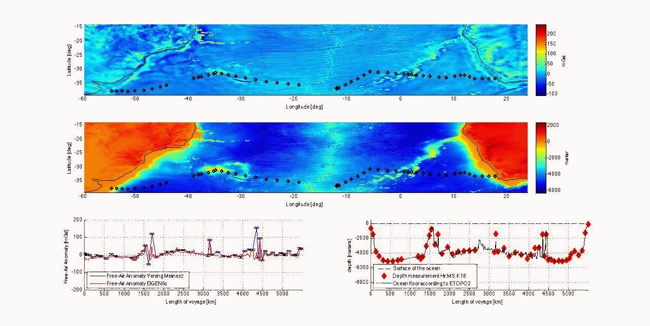
Click on the figure for a larger image. The black dots in the maps are the location of the measurements. You can clearly see the two stormy events, where it was impossible to dive (the lack of black dots). The top map shows the gravity anomalies modeled by current information and the bottom map shows the height and depth of the Earth. The two profiles underneath are the 2D representation of the gravity anomaly and depth, respectively, of the profile of the voyage. Again you can see the great accuracy of both Vening Meinesz's observations as well as the sonar depth soundings of the crew of the K18 submarine.
Some cool features can be seen in these images. Despite the height of continents (orange to red in height maps), no large positive gravity anomalies are observed. This was, according to Vening Meinesz (and also according to me), proof that continents are in isostatic equilibrium. Furthermore, you can clearly see the spreading ridge in the middle of the ocean. This is one of the important observations that proves plate tectonics is a good representation of what is going on with the surface of the Earth. Vening Meinesz did not like this theory (in 1930 this theory was considerate to be fringe science), due to the second strong gale he failed to observe this crucial piece of evidence. Maybe, if the wind gods were more favorable, he had to change his mind about plate tectonics. However, if you look at the sonar depth measurements, it is noticeable that there is this symmetry in height (don't look at the short wavelength features). The deepest depths are observed close to the continental coasts and traveling towards the middle of the oceans, the height of the ocean floor goes up almost 1.5 km. This can be explained by plate tectonics very well (maybe some other time, otherwise google it!).
He writes about the second half of the crossing that they sail over the Walfish Ridge (Walvis Ridge mister Vening Meinesz, it is a South African name). I have already written a few words about this part of the voyage, its just one of my favorite deep sea structures on Earth. The Walvis Ridge is seen both in the bathymetry as the gravity anomaly maps, revealing a NorthWestern ridge towards the African continent. As discussed in one of my previous posts, these are remnants of the still active hot spot of Tristan da Cunha. Vening Meinesz sailed over a part of the Walvis Ridge that had a double ridge. This extra feature was created in the time (70 Ma) that the spreading ridge began to migrate westward. It is however (for me) unclear what happened 70 Ma ago. As we go back in time the continents Africa and South America move further towards each other, eventually connecting at the spreading ridge. It is concluded that the continents broke up astride, or in close proximity to the upwelling plume (which is now the hotspot) (O'Connor & Duncan, 1990). Large flood basalts are found both in Namibia (African) and Brazil (South America) that can be connected to the same upwelling plume. On the West part of the South Atlantic, another large deep ocean structure is visible, the Rio-Grande Rise. All these observations give more than enough evidence for the hot spot and the movement of oceanic plates over this upwelling plume.
Vening Meinesz could not have deduced this from his measurements, but he did see the deep ocean structures with his device. This proved that global gravity measurements of Earth were very important and should be included in any geophysical research. Satellite missions like Champ, Grace and GOCE have since revealed more secrets of the deep depths of the oceans than any nerdy kid could dream off.
-Reference
J.M. O'Connor, R.A. Duncan, 1990, Journal of Geophysical Research, VOL. 95, NO. B11, PAGES 17,475-17,502


Reacties
Een reactie posten