Another blog about satellites (but they never get boring)
Satellite? But that is just a flying (we say orbiting) robot in outer space. Why am I so enthusiastic about a bit of metal rubble that is flying 7 km/s at an altitude of a few hundreds of kilometers above the roofs of our houses? Just because I can...
A few days ago Holland was in a high energy state. We broke a record. *sigh* It was the hottest day in March since...well since we measured temperature. The Dutch media had nothing else to report, but this glorious moment in history. Luckily for you guys, there is the DeepEarthScience blog!
So what did I do that day? I was standing on the roof of the tallest building in Delft looking at the city centre and thinking by myself: "This could be a good topic for the blog." The view was awesome:
In the back, a beautiful view of city center Delft in all its glory. And even further away the city of our government Den Haag. In the front-right of the picture you can see our two antennas, which we use for listening to satellites. The one in the front, a Yagi-antenna, we used that day to listen to a weather satellite (NOAA-19, an American satellite that is making pictures of Europe all the time).
This kind of satellites are good for testing your setup, because they are always on and broadcasting their signal. Our satellite sometimes doesn't have its day and is not turned on. This is especially a problem if you want to test some new equipment and the boss is looking (long story, maybe even not completely true, but...well continue with the blog).
This day we needed a satellite that really worked because I had some students to show the setup and (without announcing) ze Big Bozz had brought some people to look at our experiment. The student that operated the ground station, is a great thinker and had foreseen this, so he had chosen a pass of the NOAA-19 weather satellite. It was a high elevation (so high above in the sky) pass and the signal we received was very strong:
The center frequency of this figure is 137.100 MHz. Time runs from bottom to top. The satellite was flying over Africa-Middle East-Europe-Nord pole, drifting a little bit to the west. You can clearly see the doppler effect in the signal, a clear shift in frequency to the left (The jump at the beginning was a fiddle with the radio, not a sudden teleportation of the satellite). The signal is made of several side-bands. These bands are used to store data in the signal.
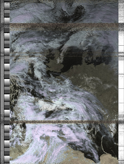
The ground station operator (the smart student) said he had an extra treat for us. He was able to decode the signal that was coming from the NOAA-19 satellite. Everybody can do this, who is a little bit handy with radio shack equipment. The signal of the NOAA type satellites are not encrypted, so if you can listen to them you are able to reproduce the following figure yourself:
You can clearly see Holland without any clouds, a beautiful day. The noise in the image is man made. We did not yet set up the automated tracking of the satellite. We have to do this ourselves so the noise is a mistake from our side. We were busy drinking coffee (engineers, you know :) ), and not paying attention to the azimuth and elevation (location in the sky) of the satellite. So after a while the satellite drifted outside the view of the antenna. This is also clearly visible in the Fourier transform of the signal (fig 2), just find the 3 resembling errors in both figures. However in the end we can say that the setup works.
And I think the last image is an even better view of Delft...


Reacties
Een reactie posten